FindIt creates StoryMaps as Outreach Tool
The Covid-19 Pandemic forced many institutions, organizations, and individuals to rethink “business as usual.” For the FindIt Program, the long-running historic resource survey program within the Center for Community Design & Preservation (CCDP), local shelter-in-place rules provided an opportunity for students to share the results of their architectural fieldwork more broadly.
Findit trains graduate students in the College of Environment and Design to identify and document historic buildings, landscapes, and other structures in cities and counties across Georgia. For the past year, FindIt’s survey efforts have been focused on Athens-Clarke County. Findit was asked by Historic Athens and the Athens-Clarke County Unified Government to conduct a historic architecture survey for the Carr’s Hill and Newtown areas in an effort to understand the history of each neighborhood and better appreciate their built resources. These types of surveys are used to promote an area’s history and guide future planning and preservation efforts.
Given the pivot to interactive online content that many non-profits were making – such as Historic Athens’ “This Moment in History” – FindIt asked Historic Athens if there was interest in a different kind of deliverable, rather than the typical printed report, and the non-profit wholeheartedly agreed. To meet this need, FindIt students began exploring ESRI’s StoryMaps as a location-based storytelling tool. StoryMaps use GIS data to showcase place-based information in an online, interactive map.
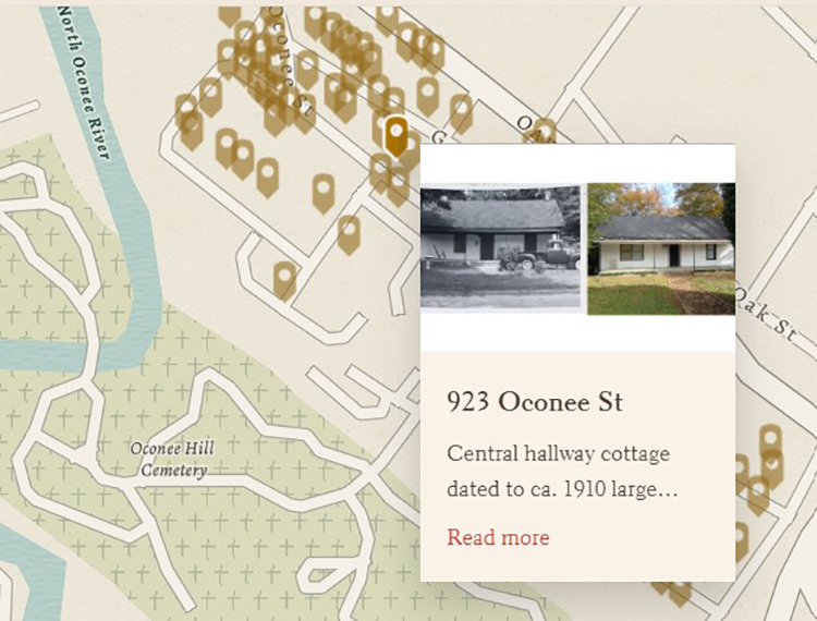
For each neighborhood, FindIt surveyors Darcie Scales and Elyse Hoganson turned their research into an interactive map displaying each surveyed property accompanied by a brief developmental history of the area, historic maps and photographs, and examples of various architectural types and styles. Viewers can explore the map by clicking on data points to bring up a recent photograph of a given property, as well as any associated information gathered during the survey process, such as the estimated date of construction, the building type, and the architectural style. For Carr’s Hill, students were also able to juxtapose contemporary images with older, archival photographs for many of the houses, thanks to a 1967 survey of Athens found on file at the UGA Hargrett Rare Book & Manuscript Library.
Cars Hill
Carr’s Hill has a long history, as it was one of the first developed areas in Athens aside from the university. The area is also a good example of houses typically built by and for workers – those in manufacturing as well as civil servants – during the early twentieth century. The Oconee Street School and the Oconee Street Methodist Church are sentinel community buildings where generations have learned and worshiped, and they continue to serve as important community resources.
Newtown
The name “Newtown” can be traced back to the late 1800s. The 1920-1921 Athens City Directory lists the residents of the Newtown neighborhood by street and nearly all the houses on Athens, Atlanta, Augusta, and Cleveland Avenues were occupied by Black residents. Though the neighborhood has evolved and changed in recent years, the neighborhood's architectural resources still reflect Newtown’s important history as a predominantly Black, working-class neighborhood.
“Unlike a static, printed report, StoryMaps are easy to share with a wider audience,” says Anders Yount, lead FindIt surveyor and dual-degree student in the Master of Historic Preservation and Master of Urban Planning and Design programs. “We hope these StoryMaps will be a fun and informative way for residents to learn about the architecture and the history of their neighborhood and community. .”
To explore the StoryMaps or to read full versions of each survey report, visit https://ced.uga.edu/pso/findit/findit_current_projects/#carrshillnewtown
FindIt is a partnership between the University of Georgia-College of Environment and Design, the Georgia Transmission Corporation, the Georgia State Historic Preservation Office (Historic Preservation Division (HPD) – Dept. of Community Affairs), the Georgia Department of Transportation, public utilities, and Georgia communities.